|
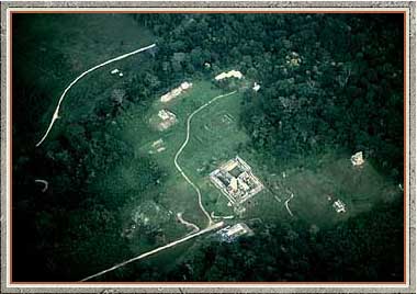
prev - home - next Aerial view of Palenque, 1960. The road from the village (today's city of Palenque was still a village in those days) comes in at the top, curves out of sight to the left, and then enters the archaeological site as the straight line at the bottom. It stops right in front of the Temple of the Inscriptions. The large mass of structures directly above this in the photograph is the Palace. The largest structure to the far right is the Temple of the Cross, and below it the Temple of the Sun. From in front of the Temple of the Inscriptions, the narrower road curves in front of the Temple of the Count and the adjacent structures of the North Group on its way to the old archaeological encampment. |
|
![]()