
| Intro 1998 1999 | Page 1 - 2 - 3 - 4 - 5 - 6 - 7 |
Previous Research
| The most complete Palenque map to date is included in Volume 1 of Merle Greene Robertson's Sculpture of Palenque series (1983). Though the best available, it contains large areas marked as "unmapped buildings". It covers roughly three square kilometers and was created through the compilation of seven separate mapping projects dating from 1891 to 1980. |
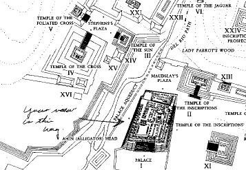
| From The Sculpture of Palenque, Volume 1 by Merle Greene Robertson. (Zoom.) |
|
The earliest of those map sources was a map of the central precinct made H.W. Price (Maudslay 1889-1902). While Price's work was accurate and detailed, it covered only a small portion of the ruins.
The first wide-reaching survey at Palenque was conducted by Franz Blom in the 1920's (Blom and La Farge 1926-7). He identified many architectural groups outside the central precinct, giving each an alphabetic designation. Unfortunately, Blom never published a complete map showing the location of individual groups in relation to the site as a whole. Finally, in 1974, Linda Schele, Jay Johnson, and Robert Rands carried out a pace and compass survey which finally joined the outer groups and the center into one map. Though never published, Schele's drawing from that 1974 survey was a major portion of Robertson's 1983 map. Since 1983 until present, the only publication pertinent to the current survey effort appears in the December 1997 National Geographic Magazine. A foldout insert within that issue presents a full color reconstruction view of Palenque's central precinct as it would have looked in the Classic Period. While the artist's reconstruction is detailed and well researched, the work of the PMP in 1998 has already changed our understanding of that same area considerably. Click here for a discussion of methodology. |