
| Intro 1998 1999 | Page 1 - 2 - 3 - 4 - 5 - 6 - 7 |
South Central Palenque, Continued
|
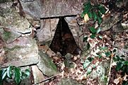
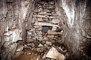
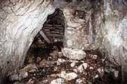
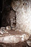
Map 4: South Central Palenque Faster download (56k file) Zoom view (160k file) The Schele Terraces, named after the late Linda Schele, are a monumental set of terraces never before recorded. Temple XXIII has always been depicted as a single structure (Maudslay 1989-1902, Robertson 1983). We now know that XXIII is in fact one part of a complex of stepped terraces reaching up from the Otulum far below. A deep arroyo feeding down into the Otulum divides the Schele Terraces into two sections, the eastern section being the more massive. The western section has 11 levels and reaches a total vertical height of 35 meters. The eastern section has 6 terraces leading up to Temple XXIII. Temple XXIII has been known for some time due to its great extent of exposed architecture. The structure has a central room with a long colonnade extending to the east containing the entrances to five looted tomb shafts. Blom's 1923 drawing depicts Temple XXIII in the same condition it stands in today. A reconstruction sketch of what XXIII might have looked like in the Classic Period appears in Figure 1. Structures XXIIIa, b, and c were located to the east and south of Temple XXIII. XXIIIa has a three sections of exposed architecture revealing two rooms and a stair case leading down. XXIIIb and c are interconnected and built into the mountain side. At a frontal height of 10 meters, XXIIIc was a surprising structure to have been overlooked by previous surveys.
Click here for a Hypothetical Reconstruction of Temple XXIII.
Map 5: Encantado Group
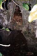
The Encantado Group is arranged around the base of a 50 meter tall hill. There are 85 structures in the Encantado group, most of which are completely buried. Two structures, EC27 and EC41, were excavated by Acosta in the 1970's (unpublished) and as a result have significant areas of exposed architecture. Acosta also excavated a trench into the north face of the Encantado Temple (EC40) exposing the wall of an interior building phase. Stretching out in front of the Encantado Group are three wide plazas, each relatively devoid of structures. The western of the three plazas contains only one structure, EC80. In seeming opposition to the 19 degrees E of N orientation common to many of the structures in the central precinct, EC80 has an orientation of 19 degrees W of N. Stela 4 was found 40 meters west of EC80, fallen and uncarved. It is 3m in length, 1m wide, and 50cm thick.
The western Encantado Group plaza also contains a small creek originating underneath the northwest corner of structure EC79. The creek runs north to the edge of the plaza where it drains underneath a terrace wall and then resurfaces, continuing north to join another creek. While no surface evidence indicates the creek is man made, its path across the plaza suggests there may be a defunct drainage system underneath the surface.
Map 8: Encantado South
The structures of the Encantado South were recorded for the first time in 1998. They are a complex of terraces and structures built into a steep hillside and facing out towards the Motiepa. All structures in the group are completely buried except structure ES12 which has exposed sections of a platform and superstructure.
Map 6: Group A
Group A extends north along the west side of the Otulum from the base of the Casteneda Escarpment down to the modern paved road. Previous maps of Group A have focused in on the area called Group I and II, a group of 11 consolidated structures, designated here as A1-3, A5, and A11-17. The PMP recorded 51 structures in Group A, the majority of which were built into the slope of the hillside. At this juncture in the PMP survey, they appear to form the primary ancient access way from the flat plains to the north up into Palenque's central precinct. The location in which Group A was built provides insight into Classic Period Palenque land use strategies. In the group's northwest section is a wide, flat area of land. Though flat land is clearly easier to build on then slopes, the flat area is completely devoid of Maya structures.
Today the area is called "Los Mangos" due to the mango grove planted there and contains only a single modern cement platform. Local informants say the structure was once the home of a German rancher who lived in Palenque during the 1960's. It seems likely that Palenque left Los Mangos clear for agricultural purposes, choosing to build instead on the slope above.
Map 7: Group E
Group E is arranged loosely along the east side of the Motiepa, north of the Encantado Temple. The group's largest architecture is located on its north end where large platforms are built out of the hillside and follow the contour of the land where it takes a natural step down. Structures E19 and E20 are the only structures in the area retaining exposed architecture. Structure E20 is in especially good condition with multiple plastered standing columns.
Map 8: Group H
Perched atop the hill above the Encantado Group, Group H is linked with the Blue Wood group on the hilltop just to the east. Both groups have large temples constructed on their northern edges, over looking the central precinct and the plains below. The view must have been breathtaking when the area was mostly cleared. Structure H1, Group H's main temple, is roughly the same size as its counterpart, Temple XXIV. The structure in the best state of preservation is H3. Due to a tree fall in its east side, three rooms can be detected in H3's floor plan. The north room (3x4m) retains its roof and can be entered through a collapsed outer wall.
The flat land in south end of Group H is littered with large limestone chunks, most with evidence of shaping. They appear to be large architectural blocks or monuments in progress. The quarry behind Temple XXVI is less than 50 meters away and is probably the stones' point of origin.
Map 9: Group J
Group J is more commonly known as Group IV. Group IV, however, is defined in past literature as the courtyard group identified here as structures J1-J8. Group J includes Group IV but extends to include the dense area of structures now recorded to its immediate east. Structures J1, J6, and J7 were partial consolidated by INAH in the 1980-90's. Most of Group J's 67 structures are completely buried. J28, J59, and J61 are the only structures in the area that have significant portions of architecture exposed. Group J's most interesting feature is its canal system. There are four separate canals, all of which join up on Group J's north side to fall off the Tak'in Ha Cascades. Each canal has sections of standing walls and begins at the base of a terrace, apparently at the mouth of an underground spring.
While the heads of the canals were not producing water during the dry season, each canal contains multiple sections where spring water was welling up and flowing. The surface evidence suggests that Group J began as an area of land riddled with bubbling springs and that the canals were built as a way to confine their flow and open land for architecture.
Map 9: Galindo and Tak'in Ha Group
First identified in Robertson's map (1983), the Galindo Group is separated from Group J by the tall hill topped by structures J58-J62. It consists of a large platform built extending off the northwest corner of Palenque's central precinct. The platform mounds are small and completely buried. On the Galindo Group's north side the hill drop fifteen meters to the Tak'in Ha group, a tiny group of structures straddling the Tak'in Ha Cascades.
Palenque has long been known for its amazing aqueducts. The 1998 survey has now expanded our understanding of water management to the residential areas of Palenque. In addition to the canal systems of Group J, the eastern Encantado Group and the Encantado South are clearly arranged around rain fed arroyos. Further, the arroyos in those areas contain evidence of retaining walls. The arroyo flowing in between the Schele Terraces is also lined with collapsed retaining walls. With few exceptions, every flowing water source, be it spring or rain fed, in central Palenque was managed and harnessed to serve the people who lived there. |

|