
| Mesoweb maps. Extreme zoom of wider area. |
![]()
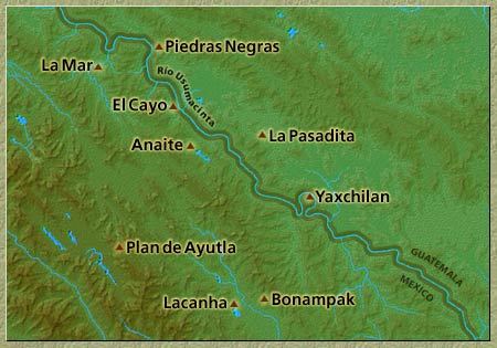
| The important and still comparatively unknown site of Plan de Ayutla is located in the Selva Lacandona in the vicinity of a number of strategically important sites along the upper Usumacinta River. It was first reported in 1974 by Peter Schmidt. Visited again in 1988 by Alejandro Tovalín Ahumada, Plan de Ayutla is currently being investigated by Luis Alberto Martos and prepared for eventual opening to the public. |  more photos |
|
In August 2004, Martos and his team discovered an interesting ballcourt marker that will be described in a future update of this report.
In a June 2004 visit to the site, it was determined that the acropolis described by Tovalín in a report to INAH on his 1988 reconnaissance is just one of three at Plan de Ayutla. One of the structures of the substantial palace on its top holds two four-storey vaults. A second acropolis is crowned by a building known informally as the Temple of the Inscription, for the significant remains of a stucco text on one of its outside walls. A nearby building, Structure 31, completely envelopes a smaller roofed structure, in a manner evocative of the pib naah sanctuaries within the temples of the Cross at Palenque. According to Martos as reported in the newspaper Cuarto Poder and reiterated during Mesoweb's visit, the ballcourt at Plan de Ayutla is the largest in the region, measuring 65 meters in length not counting its end buildings, and surpassing the ballcourts of Yaxchilan (25 meters), Piedras Negras (25 meters), Palenque (40 meters) and Tonina (60 meters). A new building with standing walls recently discovered by Martos brings the total number of acropolises to three, with an equal number of plazas in the ceremonial center. The site is said to extend over five hectares. Given its location, impressive size and ambitious architecture, Plan de Ayutla is a "strong candidate" to turn out to be the ancient site of Sak Tz'i' ("White Dog"), known from the Classic Period inscriptions but so far unlocated on the ground (Peter Mathews, personal communication 2004). Although there is no evidence as yet to tie Plan de Ayutla firmly to Sak Tz'i', its site design seems almost an imitation of the grand Acropolis at Piedras Negras, the Usumacinta powerhouse for which Sak Tz'i' seems to have served as a regional adminstrative center from time to time (Simon Martin, personal communication 2004). Judging by its appearance in the inscriptions of other sites, Sak Tz'i' was located somewhere in the Lacandon region. According to Simon Martin and Nikolai Grube (2000:146), Sak Tz'i' is known to have been defeated by Piedras Negras in AD 628 and probably fell under that kingdom's hegemony, since a ruler of Sak Tz'i' named Aj Sak Maax is said to have installed a sajal at Piedras Negras satellite El Cayo in 763. Sak Tz'i' seems to have enjoyed a superordinate status in the Bonampak-Lacanha region around 726, but the tables were turned in 787 when it was defeated by an alliance of Yaxchilan and Bonampak. Around the same time, Sak Tz'i' fell to Ruler 8 of Tonina in a "star war", and its king Stone-in-hand Star Jaguar was captured. It is known from looted monuments that Sak Tz'i' scored victories against Bonampak and possibly even Piedras Negras, but these cannot be securely dated (Martin and Grube 2000:146). After its neighbors had already succumbed to the Terminal Classic collapse, Sak Tz'i' is mentioned one last time in a carving by a sajal in 864. The continuing investigations at Plan de Ayutla by Luis Alberto Martos and his team could well turn up compelling evidence linking the site to Sak Tz'i'. And in the meanwhile, they have already established the clear importance in the archaeological record of this fascinating site in the Montes Azules Biosphere Reserve. |
home