
| Niche holding carved stone monument at the time of its discovery at Zazacatla in the Mexican highlands. Photo courtesy INAH-Morelos. (zoom) |
![]()
|
An early 1970s aerial photograph of one of the plots forming the site known as Zazacatla, just outside Cuernavaca in the Mexican state of Morelos, shows a large platform with a very large destruction hole in its southern portion. Existence of an archaeological site there in the Municipality of Xochitepec was officially reported in the middle 1980s, although no exploration was carried out. Nevertheless, knowledge of the presence of archaeological remains in this place must have existed since much earlier, given the fact that the original Mexico City-Acapulco road, built several decades ago, practically runs through the ancient site.
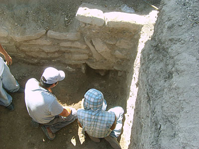
In the early 1990s, when the old Mexico City-Acapulco road was enlarged to make way for the current superhighway linking these two cities, no better consideration was shown for the site. Not only did it go unreported without any salvage archaeology ever conducted, but it was mercilessly bulldozed over, completely destroying what must have been a very interesting structure, lined with large stones, a few meters to the east of the site's two main platforms. In July, 2006, building of a parking lot started by the road leading into the town of Xochitepec, barely 50 meters to the west of the superhighway, and almost right away the building crew came across remains of an ancient wall. Archaeologist Giselle Canto intervened and the Zazacatla archaeological salvage work was begun. By then, the site had been greatly destroyed not only by the road, but by housing, a gas station, a small commercial complex, and by the facilities of several private companies. The archaeological team, headed by Canto and by Víctor M. Castro, set out to conduct research in what was left of it, before urban sprawl obliterated it entirely. After consolidating the damaged wall hit by the building crew, they began extensive test pitting throughout much of the plot. Thus, they were able to find a burial containing the remains of some ten to twelve individuals. Ceramic data collected throughout the site allowed them to establish that it was occupied between 800 and 500 BC, during the Middle Formative period (also known as the Middle Preclassic), and they were also able to identify at least six different building phases. One of the last pits, undertaken to explore an area not yet sampled, revealed a façade that was ultimately found to run along the northern edge of two adjacent platforms, placed along an east-west axis and separated by an earthen stair. The platforms were made of rammed earth and faced with stone lajas. The lower portion of much of the façade survived because it was sealed over in ancient times when a new floor was put in. Along this façade, four sculpted figures were recovered in their original position inside niches. Two of these figures display typical Olmec iconography and poses. Aside from the obvious importance of the figures found in their original context, the façade itself affords a rare and fascinating glimpse of Middle-Formative architecture. It is interesting to note in the context of the Zazacatla discoveries that a remarkable figurine in Olmec style was discovered some years ago only ten kilometers away in Atlihuayán. Also interesting to note among the excavation's preliminary results is the fact that obsidian from what appear to be numerous distinct sources has been found at the site. Given the diversity of samples, this obsidian could have come from sites far away from both the site and each other, such as Otumba, Michoacán, Cerro de las Navajas, El Chayal and Pico de Orizaba, to name a few. This suggests that the site must have been in the crossroads of important trade routes. To this day, pilgrims from Guerrero going to the Guadalupe shrine in Mexico City pass a few meters from the ancient site, which underlines its nature as a natural place of passage between Mexico's western coast and the central plateau. |
(For more photographs see Mesoweb Resources.)
 | Members of the archaeological team as they prepare to take one of the sculpted stone figures from its niche—one of four such niches in the platforms' façade. (Photo courtesy INAH-Morelos.) |
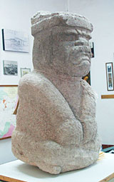
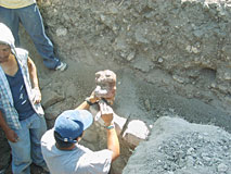 | A member of the archaeological team takes the first look at one of the four sculpted stones found inside the niches. The style of this possibly re-shaped rock cannot be readily identified as Olmec, and it may have been a representation of a dog-like beast. Both of the pieces whose style is not readily identifiable as Olmec were heavily covered with red pigment, either cinnabar or hematite. (Photo courtesy INAH-Morelos.) |
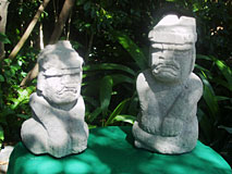 | The two Olmec-style stone effigy figures side by side. The figure on the left is 46 cm. in height; the one on the right is 58 cm. in height. (Photo courtesy INAH-Morelos.) |
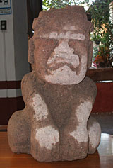
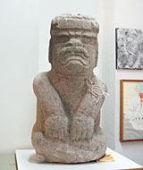 | Frontal view of the larger of the two Olmec-style anthropomorphic effigies found in niches in the northern façade of the two platforms. The figure measures 58 cm. in height. (Photo courtesy INAH-Morelos.) |
 | Three-quarters view of the larger of the two effigy figures as seen from the effigy's right. (Photo courtesy INAH-Morelos.) |
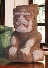
 | Frontal view of the smaller of two Olmec-style anthropomorphic figures found in the platforms' façade niches. This figure is 46 cm. in height. (Photo courtesy INAH-Morelos.) |
 | Three-quarters view of the smaller of the two Olmec-style effigies. (Photo courtesy INAH-Morelos.) |
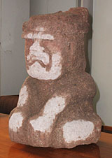 | Another three-quarters view of the smaller of the two Olmec-style effigies. (Photo courtesy INAH-Morelos.) |
 | The two Olmec-style stone effigy figures, with people included for scale. (Photo courtesy INAH-Morelos.) |
_t.jpg) | General view of the Zazacatla platforms. In the foreground is the western one, showing the laja façade and one of four niches found so far. In the background, the elevation marks the place where the Autopista del Sol superhighway goes by. (Photo: Jorge Pérez de Lara/Precolumbia Mesoweb.) | |
_t.jpg) | In the foreground, the eastern platform, with the western to the right. In the middle, remains of an earthen stair. (Photo: Jorge Pérez de Lara/Precolumbia Mesoweb.) | |
_t.jpg) | Northeastern corner of the eastern platform as liberated by excavation. (Photo: Jorge Pérez de Lara/Precolumbia Mesoweb.) | |
_t.jpg) | Stratigraphic cut in front of the northern edge of the platforms. The clearly visible white band points out the floor that ultimately sealed and protected the lower portion of the platforms' façades and its niches and sculptures. (Photo: Jorge Pérez de Lara/Precolumbia Mesoweb.) | |
_t.jpg) | Detail of one of the niches where sculpted effigies were found. (Photo: Jorge Pérez de Lara/Precolumbia Mesoweb.) | |
_t.jpg) | Archaeologist Víctor M. Castro stands in front of the northern façade of the western platform. (Photo: Jorge Pérez de Lara/Precolumbia Mesoweb.) | |
_t.jpg) | Remains of eastern façade of the eastern platform. Note the use of diagonally-placed lajas. (Photo: Jorge Pérez de Lara/Precolumbia Mesoweb.) | |
_t.jpg) | A closer, lower view of the northeastern corner of the eastern platform as liberated by excavation. (Photo: Jorge Pérez de Lara/Precolumbia Mesoweb.) | |
_t.jpg) | Ground level detail of the surviving façade of the eastern platform. (Photo: Jorge Pérez de Lara/Precolumbia Mesoweb.) | |
_t.jpg) | Remains of a structure a few meters to the east of the eastern platform. This was almost completely obliterated by the passage of the Mexico City-Acapulco superhighway. (Photo: Jorge Pérez de Lara/Precolumbia Mesoweb.) |
top - home