
| Intro 1998 1999 | Page 1 - 2 - 3 - 4 - 5 - 6 - 7 |
Central Palenque
|
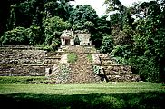
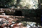
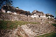
Map 3: Central Palenque Faster download (52k file) Zoom view (276k file) The central precinct of Palenque is the most extensively studied portion of the site. As early as 1891, H.W. Price had made architectural drawings and a beautiful topography map of the center (Maudslay 1889-1902). Subsequent maps of the center, most of lesser quality, were published by Noguera (1926), Escalona (1933), Fernandez (1936), and Berlin (1940). The most updated map available is published in the Sculpture of Palenque, Volume 1 (Robertson 1983). In the late 1980's and 1990's Palenque Site Director Arnoldo Gonzalez Cruz conducted multiple consolidation projects in the center, including the east side of the Palace, Temples XII and XIII, Temple X, the Ballcourt, and the Ignorado. Each of these recently restored architectural features were measured, drawn, and incorporated into the current map. The North Group was measured and drawn by Architect David Trautman. Click here for a report on his work and a discussion of the North Group's construction sequence. In addition to the well known monumental architecture, three groups of smaller structures were identified as directly associated with the center; the Camp Group, the Temple of the Inscriptions Group and the small buildings around the North Group. The Camp Group is thus named because it occupies the same area with the modern INAH archaeological camp. H.W. Price's 1891 map shows a security guard structure in the same location. Later, in the 1950's, the site museum was built there. In the 1970's the museum was converted into archaeological team quarters, lab spaces, and storage facilities and has remained that ever since. The group within which the camp sits consists of eight small structures arranged around an irregularly shaped courtyard. The Camp Group's north end is bounded by the edge of the Casteneda Escarpment. On its east side flows the Otulum, falling off the same escarpment into cascades and the Queen's Bath. A bridge in the Camp Group allows the tourist trail to cross the Otulum, providing access down to the Murcielagos Group and the modern museum. Though the top of this bridge is reinforced concrete, its architecture underneath is a corbelled arch tunnel built in the Maya Classic Period. Known since at least H.W. Price's 1891 map, it stands as a rare example of a still functioning Classic Maya bridge. The Temple of Inscriptions Group is located directly east of the temple itself, at the head of the trail leading up to the Temple of the Jaguar. Four of the group's five structures are arranged interconnected on a small plateau six meters above the plaza's elevation. The fifth structure, built into the plateau at plaza level, has been partial consolidated but never given a formal designation. This current map identifies it as structure TI5. The North Group has been historically defined as the five temples standing upon one platform designated collectively as Temple VIII. In addition to these temples, there are seven other structures of lesser size associated with the group, now designated NG1-7. NG1, located at the southeast corner of the North Group platform, is consolidated and has a south facing staircase. A series of two meter tall range structures extend from the North Group's west side for 110 meters. These structures, designated NG2, 3, and 4, bound the north edge of two open plazas, one wrapping around the Temple of the Count, the other extending south to Temple XI. Structures NG6 and 7 are low-lying platforms, located upon a terrace linking the North Group to the western edge of Group A. |
|