
| Intro 1998 1999 | Page 1 - 2 - 3 - 4 - 5 - 6 - 7 |
South Central Palenque
|
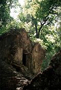
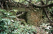
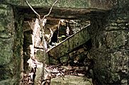
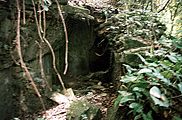
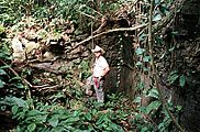
Map 4: South Central Palenque Faster download (56k file) Zoom view (160k file) South Central Palenque includes the Temple of the Jaguar and the areas designated the Blue Wood Group and the Schele Terraces. The foot trail leading to the village of Naranjo cuts between the group as it winds up the mountain side. At the northern end of the Blue Wood Group, Temple XXIV stands 12 meters in height. Descriptively named "Inscriptions Prospect", Temple XXIV looks down over the Temple of the Inscriptions. Extending from its north side are four large terraces which stair-step down the steep hillside to the back of Temple XII. Today, when one stands in front of the Temple of Inscriptions they see the temple's roof comb with wooded hillside towering above. Temple XXIV and its northern terraces, now covered, would have made the entire hillside appear as one massive temple, dwarfing the Temple of Inscriptions below. (Photo) The rest of the Blue Wood Group snakes back to the south following the shape of the flat ridge top and arranged around two main structures, Temples XXV and XXVI. Temple XXVI is in an excellent state of preservation. A measured drawing of its exposed architecture was made and incorporated into the map. A similar drawing made by Blom demonstrates the building was in the same condition at least as early as 1923. On the northeast corner of Temple XXVI's frontal patio lies Stela 3. Broken, fallen, and uncarved, it was easily over looked by earlier projects. Though fragmented and eroded, its dimensions can be estimated at 2.5m high, 70cm wide, and 40cm thick. Directly south of Temple XXVI, on the hillside above, lies the first limestone quarry identified at Palenque. An outcrop of limestone, approximately 30m in length, has partially carved blocks strewn in front of it. It stands to reason that the Blue Wood Group was connected in some way to the exploitation of this nearby resource. |
|